Geoverse MDM (Massive Data Manager)
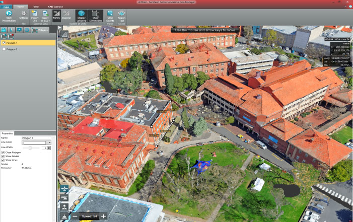
Geoverse MDM is a revolutionary new geospatial software that enables users to visualize, manipulate and interact with point cloud data – regardless of size – without loading times. Geoverse MDM point cloud rendering is based on Euclideon’s revolutionary Unlimited Detail (UD) technology. This technology is able to handle the vast amounts of LiDAR data — which can be produced at rates of up to two million points per second — in a way previously unimaginable on normal computers.
Watch on Youtube!
Case Study – City of Budapest
Reasons why customers choose Geoverse
 CONNECT TO AUTOCAD®
Create AutoCAD® drawings in real time using the full resolution of your data. This eliminates the need for exporting shape files from Geoverse MDM and means that users can leverage their existing investment in their design products and take advantage of centrally stored LiDAR repositories streamed over the Internet.
 COMBINE DATASETS
Overlay your point cloud and image data with other datasets for a better quality assessment of the data.
 LOAD DXF FILES (UnlimitedOrtho)
Overlay cadastral boundaries/ seamlines onto orthophotos and for Quality Controls or update of the cadastral boundaries
 ACCURATE MEASUREMENTS
Take measurements at the precision of the data set; –
 CREATE ANNOTATIONS
Create annotated presentations with bookmarks and labels; –
 CENTRAL STORAGE
Place your data in one place on the network and stream simultaneously to multiple users; no need to copy onto every computer.
 INTERNET ACCESS
Access your data thousends of kilometres away from the central storage (secure Internet streaming) on your computer/ tablet, mobile phone
 CAD MODELS
Visualization of gigantic CAD models with an unlimited number of surfaces in real time
 SUPPORT FOR INTENSITY & CLASSIFICATION
Render point clouds using their Intensity and Classification values. Enable/disable classified points in real time without re-processing. Place Intensity and .LAS standard classification data into UDS files
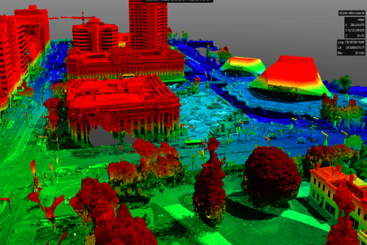 COLOURIZE TOOLS
Colourize point clouds in real time by using elevation or drawing contour lines at fixed intervals. Every part of the rendering can be controlled, including colours and opacity levels. No off-line processing is required
 CREATE CONTOUR LINES
Visualize Contour lines in real time for better interpretation of the data.
 OVERLAY DIFFERENT DATASETS
Overlay data onto base maps, including OpenStreetMap and Bing Street, Aerial & Hybrid. –
Benefit from our customization service in order to adapt Geoverse to your specific needs (e.g. Database Connection)
Technical requirements for Geoverse View
Minimum System Requirements
Computer Processor (CPU): 32bit 1.5 GHz Computer Memory (RAM): 1 GB Hard Disk (HDD): 1.5gb available space, 5400 rpm Graphics Card (GPU): DirectX 9 Compatible Operating System (OS): Windows Vista®,
Recommended System Requirements
Computer Processor (CPU): 64bit 3.0 GHz Quad Core Computer Memory (RAM): 2 GB Hard Disk (HDD): 2TB 7200 rpm Graphics Card (GPU): DirectX 9 Compatible Operating System (OS): Window 7
Request a demo now!
E-Mail office@meixnerimaging.com and include your full Name, Company, Phone, Website, and Country.
MEIXNER IMAGING GMBH is the official distributor for Euclideon’s ready-made Geoverse software.
Visualization and Manipulation of unlimited amounts of data in realtime from anywhere in the world. Our products open the door to a wide range of revolutionary new applications across the industries.